⚠️ TESTING IN PROGRESS — This site is under active development. Features, pricing and licensing are not finalised.
🚛

Logistics 4×4

Cross-border fleet communications for small operators. Four SIM callers and four P2P video peers share a single call space — driver at the border, head office, customs, customer — all in the room at once. Live maps, GPX routes, cargo manifests, translated voice chat and emergency broadcasts, all on a standard Android phone.

📹 4 video peers 📞 4 SIM callers 🗺 Live maps + GPX 📍 POI layer 🧭 Offline compass 🌍 15 languages 📋 Manifest + run sheet 🚨 Emergency broadcast 📟 Emergency Mode — SMS & peer
🚛
Logistics 4×4
● Fleet online
📋 Cross Waypoint 3 — stay on B4301
🇩🇪 → 🇬🇧: “Customs cleared, proceeding to gate 7”
En route — ETA 14 min
Customer on SIM — connecting now…
📍 Location shared with fleet
🎥 Dispatch 🎥 Driver B 📞 Customs 📞 Customer 🗺 Map 🧭 Compass

The 4×4 call space

SIM phone calls and P2P video share one connected space

One call space — eight participants

📞 4 SIM callers

  • Standard cellular voice
  • No internet required
  • Customs officer
  • Customer abroad
  • Head office landline

📹 4 P2P video peers

  • WebRTC — no server bill
  • Full mesh video + audio
  • Driver to driver
  • Dispatch controller
  • Remote team member
Audio from SIM calls is hardware-merged into the group call via Android's telecom stack or Bluetooth SCO — earpiece only, private.

Logistics 4×4 does not aim to replace a professional proprietary logistics platform like those used by large courier networks. It fills the gap for small operators, sole traders and situations a big-enterprise tool cannot reach — a driver at a remote border crossing who needs to connect instantly with head office, a second driver three miles back, the customs inspector in the booth, and the customer in another country who can only dial in by phone.

Who it is for

Designed for high-stakes, low-infrastructure field communications

🛃

Border crossing

Driver connects the customs officer (SIM call), head office (video), the receiving customer (SIM call) and a second driver in convoy (video) — all simultaneously, with live translated chat visible to everyone.

🚚

Long-haul convoy

Trucks spread over 50 miles stay in a shared call with push-to-talk, location sharing on the same live map, and dispatcher route pushes arriving as GPX files loaded directly in the map.

🏕

Off-road / trekking

No data signal? The offline compass shows bearing arrows to every other fleet member. POI pins mark fuel stops, hazards and rendezvous points — embedded in a pushed GPX file or dropped by any driver on the map. Long-range hotspot links between trucks with directional aerials can reach 50+ miles.

🌐

Multilingual teams

Push-to-talk transcribes speech, detects the speaker's language, translates, and delivers text + audio in each listener's own locale — 15 languages, powered by a local Argos Translate server on the phone.

📦

Proof of delivery

Driver scans the depot QR code to load the manifest, then scans the customer POD QR on delivery. Refused delivery? Capture a photo and a written exception note. Customer signature captured on screen.

🏢

Dispatch office

Dispatcher screen shows all drivers on the live map, runs the run sheet, pushes manifests and routes to individual drivers over the peer channel, and broadcasts emergency alerts fleet-wide.

Live Map, POIs & Compass

OSM, satellite and hybrid layers — peer locations, GPX routes, points of interest and offline tile cache

📍
🚛
🚚
🏢
⚠️
Street Satellite Hybrid GPX route POI layer Offline cache
OpenStreetMap tiles Esri World Imagery 2.5D buildings OSRM routing Nominatim place search Disk tile cache POI layer
📍 Route waypoints 📍 IDE-pushed 📍 Driver-dropped
🗺

Three map layers

Cycle between Street (OpenStreetMap), Satellite (Esri World Imagery) and Hybrid (satellite base + OSM road overlay) with a single tap. All tiles are disk-cached — previously viewed areas load offline without data.

📍

Peer locations on the map

Every fleet member who enables location sharing appears as a live pin. Tap a pin to see their name and ETA. Dispatcher can see the whole fleet at a glance without a separate tracking platform.

📁

GPX route push

Office pushes a .gpx route file from Chameleon PC directly to a driver's phone over the peer channel. The route loads instantly in the map as a coloured overlay. Recent routes are stored locally for reuse. Supports GCJ-02 coordinate offset correction for China.

🔄

Compass-lock or north-up

Map rotates live with the device compass for heads-up driving orientation, or locks north-up for traditional map reading — toggle in settings per driver preference.

🧭

Compass screen — offline peer navigation

No data? The full-screen compass rose shows a bearing arrow for each online peer using last-known GPS. Peer distances and compass headings update from cached locations — useful for trekkers, off-road convoy navigation and mountain rescue coordination.

📍

Points of Interest (POI) layer

Three sources of POIs shown as colour-coded pins on the map. Amber pins come from <wpt> waypoints embedded in a GPX file — they load with the route and clear with it. Green pins are pushed directly from the Chameleon PC IDE (fuel stops, hazards, delivery addresses) independently of any route. Red pins are dropped by the driver with a long-press on the map. All POIs persist across sessions; tap any pin to navigate, open in Maps, or delete. Icons adapt to type: ⛽ fuel, 🚚 delivery, ⚠️ hazard, 🏥 hospital, 🅿️ parking, ✈️ airport and more.

All features

Every screen and service in the app

PEERS
📹

Group P2P Video

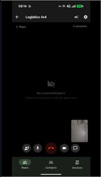
Full-mesh WebRTC video and audio for up to 4+ peers — no central media server, no monthly call bill. Adaptive grid: 1 peer = full screen, 2 = side-by-side, 3 = 2+1, 4 = 2×2. Local feed floats as picture-in-picture. Bitrate scales per peer (1.5 Mbps → 350 Kbps) to keep quality even at every group size. Incoming calls ring and vibrate even when the app is in the background.

WebRTC full-meshAdaptive gridPiP localRing + vibrate
SIM BRIDGE
📞

SIM Call Bridge

In a cellular call and want to pull in a P2P peer? Tap Add to group — Android's telecom stack registers the WebRTC session alongside the SIM call and presents a native "Merge calls" option. Audio mixing happens in the telephony chip — earpiece only, fully private. When the device or carrier doesn't support hardware conference, Bluetooth SCO headset routing is used as a fallback.

Hardware conferenceBT SCO fallbackEarpiece only
COMMS
🗣️

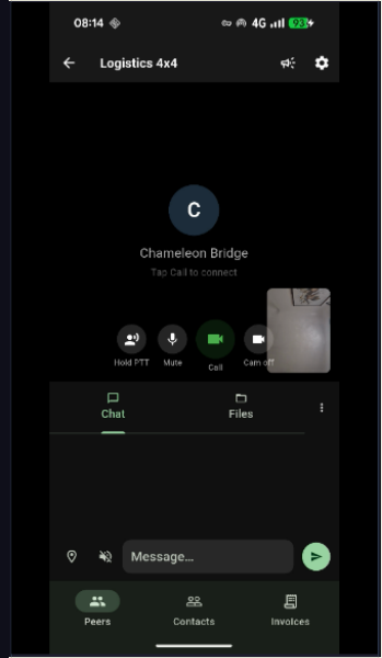
Push-to-Talk + Live Translation

Hold the PTT button to speak — Android's speech recogniser (16 kHz, 16-bit) transcribes to text in real time. The detected language is sent to an on-device Argos Translate server. Each listener receives the message translated into their own selected locale and read aloud by TTS. Partial transcriptions stream as a live typing indicator while recording. Works over the P2P channel or standalone over a hotspot.

Auto language detectArgos TranslateLive TTS readout15 languages
BROADCAST
🚨

Ticker & Emergency Broadcast

Dispatcher broadcasts a message fleet-wide — it appears as a full-width ticker bar at the top of every screen. Four priority levels: Emergency (flashing red, rate-limited per sender), Important (red on white), Instructions (black on green), Info (yellow on black). Messages can trigger TTS readout on recipient phones. Configurable TTL: 1 minute to “until dismissed”.

Fleet-wide broadcast4 priority levelsTTS readoutAuto-expire
DISPATCHER
🗂

Dispatcher Dashboard

Three-tab dispatcher view: Drivers (live positions, push manifests, assign routes), Run Sheet (drag-to-reorder multi-drop stops, tap-to-cycle status, CSV import/export) and Cargo Manifest (QR scan loading at depot, POD QR scan at delivery). Dispatcher can push GPX routes and invoice files directly to individual drivers over the peer channel.

Driver trackingManifest pushRoute push
MANIFEST
📦

Cargo Manifest

Scan the depot QR code to load items onto the manifest. At delivery, scan the customer's POD QR to mark delivered. Exception handling: refused delivery logs a photo and written note; safe-drop records a photo of the drop location; customer signature is captured on the touchscreen. All events are timestamped with GPS coordinates.

QR scan in/outPhoto PODScreen signatureGPS timestamps
RUN SHEET
🛣

Run Sheet

Multi-drop delivery list with drag-to-reorder stops. Tap the status icon to cycle each stop: Pending → Arrived → Delivered. Tap any address to open it in the phone's map app for turn-by-turn navigation. Import from CSV — header-aware, compatible with Onfleet, Routific, Circuit and custom exports. Export to CSV and share via the system share sheet.

Drag reorderCSV importOnfleet / Routific compatibleShare export
INVOICES
🧾

Invoices

Create, print and share invoices directly from the phone. Office can push a pre-prepared invoice from the Chameleon PC accounting module to the driver over the peer channel — the driver reviews, signs and sends it on the spot. Role-gated accounting dashboard: guest (totals only), operator (full transactions + invoices) and admin (MTD submit + QR access grants).

Push from PCPrint / PDFRole-gated
EMERGENCY
📟

Emergency Mode — SMS & Peer

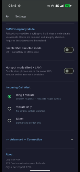
No data? The app falls back to a compact coded protocol. Driver (D), Hiker (H), and Emergency Services (X) profiles share a universal alert scale. GPS coordinates embed automatically. Messages are decoded and read aloud by TTS on receipt. A99+H99 is the universal SOS — broadcast to all contacts and fleet peers in one tap. When data is available, frames travel over the peer channel instead of SMS — selectable per send: SMS only, Peers only, or Both.

3 user profilesGPS embeddedTTS decodeMETHANE aligned SMS · Peers · Both 📋 Code reference →
CONTACTS
👥

Contacts & Groups

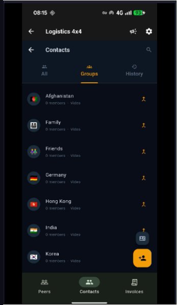
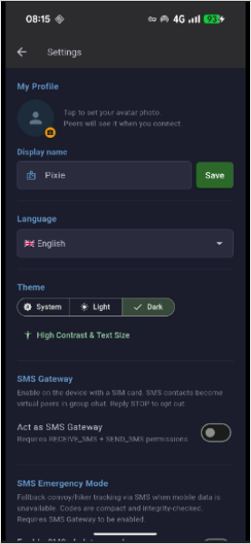
Unified contact book combining SIM phone numbers, Tailscale peer IDs and mixed groups. Create a Border Team group containing two P2P peers and a SIM number — tap the group to start a call to all three. Call history with timestamps. Per-contact avatar photos. Each fleet member sets a profile photo in Settings — it is shared automatically over the signal channel when they connect, so every peer sees a real photo instead of an initial letter.

SIM + peersMixed groupsCall historyAvatar sharing
NETWORK
📶

Flexible Networking

Connect via Tailscale (remote, over the internet) or direct LAN / hotspot — useful for trucks in convoy or where a long-range directional aerial is fitted (50+ miles in open terrain). mDNS auto-discovery finds other fleet phones on the same Wi-Fi without entering IP addresses manually.

Zero-config hub election — when no PC is running, phones automatically elect a hub: the fleet member with the lowest Tailscale IP becomes the signalling hub and the rest connect as spokes. No configuration required. IP address fields offer tap-to-fill autocomplete from the probed Tailscale device list, with green/grey reachability indicators updated every 30 seconds.

TailscaleLAN / hotspotmDNS discoveryZero-config hub election50+ mile hotspot range
FLOAT
🪟

Floating Overlay

The app can float as a persistent overlay above all other apps — useful when a driver needs to check navigation while keeping the call active in a corner of the screen. Incoming peer calls bring the overlay to the front automatically with ring + vibration, ensuring the driver never misses an urgent call from dispatch.

Always-on-top overlayAuto-bring-to-frontRing + vibrate
CHAMELEON
🖥️

Chameleon PC Integration

Connects to the Chameleon AI IDE on a desktop or office PC via WebSocket. The office can push GPX routes, POI sets, invoice PDFs and manifest data to drivers over the always-on signal channel — no active video call required. The signal server runs on the PC or any phone; no cloud relay needed.

IDE beacon modes — the PC broadcasts a UDP signal to all fleet phones automatically: Mandatory forces all phones to connect to the PC server immediately; Optional connects idle phones (phones in a live P2P call reconnect when the call ends); Off lets phones self-elect a hub by lowest Tailscale IP. Switch modes at runtime via a simple REST call or from the IDE UI toggle.

Route pushPOI pushInvoice pushNo cloud relayUDP beacon auto-connectMandatory / Optional / Off

15 languages

Full UI translation plus live PTT speech translation powered by on-device Argos Translate

🇬🇧 English 🇨🇳 中文(简体) 🇫🇷 Français 🇩🇪 Deutsch 🇪🇸 Español 🇯🇵 日本語 🇷🇺 Русский 🇰🇷 한국어 🏴󠁧󠁢󠁷󠁬󠁳󠁿 Cymraeg 🇧🇷 Português 🇸🇦 العربية 🇮🇳 हिन्दी 🇵🇱 Polski 🇷🇴 Română 🇻🇳 Tiếng Việt
🎤

Auto language detection

The PTT service detects the speaker's language automatically — a German-speaking driver and a Spanish-speaking dispatcher can push-to-talk freely without selecting a language each time.

🔒

On-device translation — no cloud

Translations are handled by an Argos Translate server running locally on the phone inside Termux. Speech and text never leave the device for translation. Works offline once language packs are installed.

🔊

TTS in the listener's language

After translation each message is read aloud in the receiver's locale using Android TTS — the listener hears the translated message even without looking at the screen, ideal for a driver keeping eyes on the road.

Emergency Mode — SMS & Peer Channel

A compact code protocol that works over SMS when data is gone, or over the fleet peer channel when it isn't

📟

Dual transport — SMS or peer channel

When there is no mobile data — deep in the bush, at a remote border crossing, or during a network outage — Logistics 4×4 sends coded status frames over standard SMS. When data is available, the same frames travel over the fleet peer channel at full speed. A per-send selector lets you choose SMS only, Peers only, or Both. SOS always fires on every available channel simultaneously regardless of the setting.

👥

Three profiles — one shared language

Codes are organised into three user profiles that share a common alert vocabulary: D — Driver (border, cargo, convoy, fuel, road conditions), H — Hiker (vitals, trail, gear, check-in schedule), and X — Emergency Services (triage, incident type, resources on scene, evacuation status). An SOS from any profile is understood by all.

🏥

Aligned with international emergency standards

The Emergency Services profile uses the international P1–P4 triage scale (Immediate / Delayed / Minor / Expectant) and incident categories aligned with the METHANE major-incident framework used by joint emergency services worldwide. A paramedic or SAR coordinator joining a cross-agency operation will recognise the terminology immediately.

🔊

Auto-read on receipt

Incoming coded messages are decoded and read aloud by text-to-speech — a driver keeping eyes on the road or a responder with hands occupied hears the full plain-English meaning of every code without touching the phone. Corrupted messages trigger an automatic resend request.

Example coded messages
Driver — fuel stop, customs delay
D22 F44 B22
Driver on stop · Fuel quarter · At customs queue
Hiker — injury, requesting help
V66 H44 A55 + “ankle fracture cannot walk”
Serious injury stopped · Need rescue team · Urgent
Emergency services — RTC, P1 casualties
I22 P44 N22 R33 H33
Road traffic collision · P1 life-threat casualties · 2–5 persons · Ambulance on scene · Air ambulance required
Universal SOS — any profile
A99 + H99
SOS with GPS location — sent to all registered contacts immediately
📋
Field Code Reference
All codes for all profiles — print and carry

The complete code table for Driver, Hiker, and Emergency Services profiles. Download as PDF and keep a copy on your phone, in the cab, or in your pack.

📥 View & download code reference

Designed around the gap

Not a replacement for enterprise logistics software — a solution for where enterprise software isn't

💰

No per-seat, per-driver bill

WebRTC peer calls are direct phone-to-phone with no media relay server and no monthly per-user fee. The app runs on standard Android phones the team already carries.

🌐

Works where enterprise apps don't

Designed for border crossings, remote terrain and international operations where standard logistics apps assume a fast, reliable data connection. Falls back to offline compass and cached maps when data disappears.

📱

Standard Android phone

No specialist hardware. No MDM enrolment. Any Android 7.0+ phone (minSdk 24) running the APK is a full fleet node. A long-range hotspot aerial fitted to a truck cab can extend P2P coverage to 50+ miles in open countryside.

🚀

Future roadmap

Planned additions include full tachograph compliance, duty-hour monitoring, DVSA digital tachograph integration and KML/GeoJSON import for POI bulk upload. The foundation is already built.

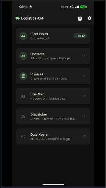
App Screenshots

Logistics 4×4 — captured live on device

Interested in Logistics 4×4?

Currently in testing — contact us to discuss a pilot, request a build or ask about licensing for your fleet.

Get in touch ← Companion App ← Overview